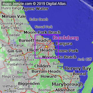
myBonzle menu: Add to my places Add picture Add story Add note Skip to map Bundaberg is located on the Burnett River in southeast Queensland a distance of about 300km north-northwest from Brisbane (show me). Bundaberg has a population of around 45,000 and is one of the larger cities in Australia. Bundaberg is about 17m above sea level. The nearest more populous place is the city of Rockhampton which is 250km away with a population of around 59,000 (show me a map with Bundaberg and Rockhampton). The centre of Bundaberg is at the intersection of the Bundaberg Gin Gin Road, the Isis Highway and the Bundaberg Bargara Road.
Bonzle users have said that the facilities at Bundaberg include an airport, bmx track, caravan park or parks, child care centre, children's playground, community centre, community hall, cricket pitch, cycle paths, fire & rescue service, fire station, health centre, high school, hospital, hotel/motel, library, marina, medical centre, playing fields, police station, pre school, primary school, railway station, service station, showground, skateboard park, sportsground, swimming pool, tennis courts and university. Do you know of other facilities available at Bundaberg? Is this list accurate? Contribute your knowledge by clicking here. Bonzle users have reported that breadfruit, chamomile, evening primrose, macadamia nuts, mangoes, mung beans, okra, peas, rockmelon and zucchini grow at Bundaberg. Are you a keen gardener? Do you know of other plants that grown in Bundaberg? Is this list accurate? Contribute your knowledge by clicking here. Do you know whether any feral animals, insects and weeds have invaded Bundaberg? Contribute your knowledge by clicking here. Do you know of any agricultural activities in Bundaberg? Contribute your knowledge by clicking here.If you're interested in Cities, Towns and Villages then you may also be interested in Suburbs/Regional Areas. |