Map of Mount Elliot Mine, QLD

home > mines > Mount Elliot Mine > map of Mount Elliot Mine
bonzle.com logo
Description
General
Weather
FAQ
LGA
Terrain
Map Includes
>>>Contribute
Pictures
Notes
Stories
Submit website

 myBonzle menu: Add to my places   Add picture   Add story   Add note   

Skip to map  

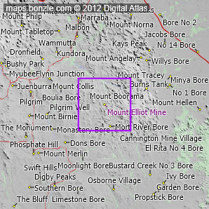
The Mount Elliot Mine is a copper and gold mine.1

The Mount Elliot Mine is a mine in west Queensland, Australia situated about 1430km west-northwest of Brisbane (show me). The Mount Elliot Mine is about 393m above sea level. The Mount Elliot Mine is one of the westernmost mines in Queensland.

The Mount Elliot Mine is a copper and gold mine. Do you know what else was or is being mined at the Mount Elliot Mine? If you do, why not contribute your knowledge by clicking here.

The nearest populated place is the town of Cloncurry which is 92km away with a population of around 2,700 (show me a map with Mount Elliot Mine and Cloncurry).

The nearest sealed road to Mount Elliot Mine is the Cloncurry Dajarra Road (56.6km away).

1Blake, D.h., Jaques, A.l., & Young, G.a., 1983. Geology Of The Selwyn Region. Bureau Of Mineral Resources, Geology And Geophysics

Featured picture

Mount Elliot Mine
click here for 16 more pictures...


Mount Elliot Mine Weather
17 minutes ago
 ValueTrend
Temp12.7°Ccooling
Feels like7.7°Cwarming
Wind9-11km/h
W
calming
Pressure1017.7hPasteady
Rain since 9am0mmN/A
Observation taken 52km
to the southeast (highlight point)
1/9/17 5:00AM (EST); 4:00AM (CST); 3:00AM (WST)
more info...

Do you have a photo of Mount Elliot Mine gathering cyber dust on your hard drive?   Why not upload it and share your information with other Bonzle users.   Click here to view recently uploaded photos from other users or browse thousands of pictures grouped by themes in Bonzle collections.   Here are some examples:

Jerilderie Sydney Opera House Lake Dyer Mena Creek

Not the 'Mount Elliot Mine' you were after? Try the other Mount Elliot Mine near Corryong in Victoria.

Create a custom map: Click here to create a custom map including 'Mount Elliot Mine'

Link to this page: Click here to see how

Map of Mount Elliot Mine in Queensland
Click on the name of a place to go to the Bonzle page for that place. For other clicks on the map, select what click action you want below, then click on the map where you want that action performed.

ZOOM IN  ZOOM OUT  PAN/MOVE  GET HEIGHT/DEPTH & POSITION

scroll up and leftscroll up and leftscroll upscroll upscroll upscroll up and rightscroll up and right
scroll up and left
scroll up and right
scroll left
scroll left
scroll left
scroll right
scroll right
scroll right
scroll down and leftscroll down and right
scroll down and leftscroll down and leftscroll downscroll downscroll downscroll down and rightscroll down and right
< MAX INCLICK IN THE SHADED BAR BELOW TO SET THE ZOOM LEVELMAX OUT >
zoombar
Map Legend
8km
mapscalemapscalemapscale
5mi
colour of populated areasPopulated Areascolour of sandSand
colour of reserves and parksReserves and Parkscolour of native vegetationNative Vegetation
What's nearby
hide
myBonzlehide
Sign In | Not a member? Join now!
Searchhide
Position within Australiahide
Your locationhide
Places last visitedhide

Dyers Falls in Victoria
Railway Bore in South Australia
Wyndham in Western Australia
Beulah in Victoria

Your screen sizehide

640 | 800 | 1024 | 1280 | 1400 | 1600

©2017 Digital Atlas Pty Limited | Usage Terms | Data Sources
If you do not agree with the Usage Terms then do not access this website.