Map of Mount Bauple Mine, QLD

home > mines > Mount Bauple Mine > map of Mount Bauple Mine
bonzle.com logo
Description
General
Weather
FAQ
LGA
Terrain
Map Includes
>>>Contribute
Pictures
Notes
Stories
Submit website

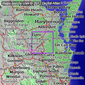
 myBonzle menu: Add to my places   Add picture   Add story   Add note   

Skip to map  

Featured picture

Bauple Fauna an Reptile Reserve
click here for more pictures...

The Mount Bauple Mine was an underground graphite mine (now abandoned).1

The Mount Bauple Mine in Queensland is a mine about 190km north-northwest of Brisbane (show me). The Mount Bauple Mine is at an elevation of approximately 288m above sea level.

The Mount Bauple Mine was a graphite mine. Do you know what else was being mined at the Mount Bauple Mine? If you do, why not contribute your knowledge by clicking here.

The nearest populated place is the village of Tiaro which is 8.8km away with a population of around 360 (show me a map with Mount Bauple Mine and Tiaro).

The nearest sealed road to Mount Bauple Mine is the Bruce Highway (1.4km away).

1Cranfield L., & Garrad P., 1991. Mineral Occurrence Data Sheets - Maryborough 1:250 000 Sheet Area, Metallogenic Studies Program (data Supplied On Diskette). Queensland Resource Industries Record

Would you like a wall map of Australia? 76.2 cm x 68.58 cm unlaminated or laminated maps are available.

Do you have a photo of Mount Bauple Mine gathering cyber dust on your hard drive?   Why not upload it and share your information with other Bonzle users.   Click here to view recently uploaded photos from other users or browse thousands of pictures grouped by themes in Bonzle collections.   Here are some examples:

Drayton Dulacca Town Hall Scenic Hill

Create a custom map: Click here to create a custom map including 'Mount Bauple Mine'

Link to this page: Click here to see how

Map of Mount Bauple Mine in Queensland
Click on the name of a place to go to the Bonzle page for that place. For other clicks on the map, select what click action you want below, then click on the map where you want that action performed.

ZOOM IN  ZOOM OUT  PAN/MOVE  GET HEIGHT/DEPTH & POSITION

scroll up and leftscroll up and leftscroll upscroll upscroll upscroll up and rightscroll up and right
scroll up and left
scroll up and right
scroll left
scroll left
scroll left
scroll right
scroll right
scroll right
scroll down and leftscroll down and right
scroll down and leftscroll down and leftscroll downscroll downscroll downscroll down and rightscroll down and right
< MAX INCLICK IN THE SHADED BAR BELOW TO SET THE ZOOM LEVELMAX OUT >
zoombar
Map Legend
8km
mapscalemapscalemapscale
5mi
colour of populated areasPopulated Areascolour of sandSand
colour of reserves and parksReserves and Parkscolour of native vegetationNative Vegetation
What's nearby
hide
myBonzlehide
Sign In | Not a member? Join now!
Searchhide
Position within Australiahide
Your locationhide
Places last visitedhide

Gloucester in New South Wales
Minnipa in South Australia
Orbost in Victoria
Blackall in Queensland

Your screen sizehide

640 | 800 | 1024 | 1280 | 1400 | 1600

©2014 Digital Atlas Pty Limited | Usage Terms | Data Sources
If you do not agree with the Usage Terms then do not access this website.