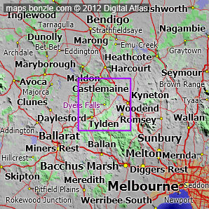
myBonzle menu: Add to my places Add picture Add story Add note Skip to map Dyers Falls is a waterfall located on a tributary of the Loddon River in central Victoria a distance of about 90km northwest from Melbourne (show me). Dyers Falls is at an elevation of approximately 445m above sea level. We estimate that Dyers Falls is between 30m and 44m high. This estimate is based on analysis of the topographic profile around the waterfall and may not be an accurate figure for the total fall of water seen if viewing the falls. The nearest populated place is the town of Daylesford which is 14km away with a population of around 3,400 (show me a map with Dyers Falls and Daylesford). The nearest sealed road to Dyers Falls is the Daylesford-Malmsbury Road (3.88km away).
Bonzle users have said that the facilities at Dyers Falls include picnic tables. Do you know of other facilities available at Dyers Falls? Is this list accurate? Contribute your knowledge by clicking here. Are you a keen bird watcher? Have you been bird watching at Dyers Falls? What birds have you seen at Dyers Falls? Contribute your knowledge by clicking here. As a Bonzle sub-project, we're trying to build Australia's most comprehensive bird location atlas. A big thankyou to all that have contributed and continue to contribute sightings. If you're interested in Waterfalls then you may also be interested in Rivers and Creeks, Springs, Lakes and Dams and Gorges. |