Map of Willunga, SA

home > cities, towns and villages > Willunga > map of Willunga
bonzle.com logo
Description
General
Weather
People
FAQ
LGA
Terrain
Similar
Map Includes
>>>Contribute
Pictures
Notes
Stories
Submit website

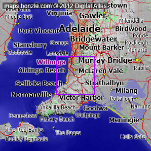
 myBonzle menu: Add to my places   Add picture   Add story   Add note   

Skip to map  

Featured picture

Willunga Railway Line
click here for more pictures...

Willunga is located just off the Little Road near the Southern Ocean. It is 38km south of Adelaide (show me). Willunga has a population of around 1,900 and is one of the smaller towns in Australia. Willunga is at an altitude of about 120m above sea level.

The nearest more populous place is the town of McLaren Vale which is 5.9km away with a population of around 2,600 (show me a map with Willunga and McLaren Vale).

Do you know what facilities are available at Willunga? Contribute your knowledge by clicking here.

Are you a keen gardener? Do you know what edible garden plants grow at Willunga? Contribute your knowledge by clicking here.

Do you know whether any feral animals, insects and weeds have invaded Willunga? Contribute your knowledge by clicking here.

Do you know of any agricultural activities in Willunga? Contribute your knowledge by clicking here.

If you're interested in Cities, Towns and Villages then you may also be interested in Suburbs/Regional Areas.

Do you have a photo of Willunga gathering cyber dust on your hard drive?   Why not upload it and share your information with other Bonzle users.   Click here to view recently uploaded photos from other users or browse thousands of pictures grouped by themes in Bonzle collections.   Here are some examples:

Wallsend Snug Glenroy Karalundi

Not the 'Willunga' you were after? Try: Willunga (the homestead) near Mount Gambier in South Australia; or Willunga (the regional area) in South Australia.

Create a custom map: Click here to create a custom map including 'Willunga'

Link to this page: Click here to see how

Map of Willunga in South Australia
Click on the name of a place to go to the Bonzle page for that place. For other clicks on the map, select what click action you want below, then click on the map where you want that action performed.

ZOOM IN  ZOOM OUT  PAN/MOVE  GET HEIGHT/DEPTH & POSITION

scroll up and leftscroll up and leftscroll upscroll upscroll upscroll up and rightscroll up and right
scroll up and left
scroll up and right
scroll left
scroll left
scroll left
scroll right
scroll right
scroll right
scroll down and leftscroll down and right
scroll down and leftscroll down and leftscroll downscroll downscroll downscroll down and rightscroll down and right
< MAX INCLICK IN THE SHADED BAR BELOW TO SET THE ZOOM LEVELMAX OUT >
zoombar
Map Legend
8km
mapscalemapscalemapscale
5mi
colour of populated areasPopulated Areascolour of sandSand
colour of reserves and parksReserves and Parkscolour of native vegetationNative Vegetation
What's nearby
hide
myBonzlehide
Sign In | Not a member? Join now!
Searchhide
Position within Australiahide
Your locationhide
Places last visitedhide

Bogong in Victoria
Dederang in Victoria
Point Lonsdale in Victoria
Kiewa Valley Highway in Victoria

Your screen sizehide

640 | 800 | 1024 | 1280 | 1400 | 1600

©2019 Digital Atlas Pty Limited | Usage Terms | Data Sources
If you do not agree with the Usage Terms then do not access this website.