Frequently asked questions about Bywong Town Mining Village, NSW

home > localities > Bywong Town Mining Village > frequently asked questions about Bywong Town Mining Village > zoomed
bonzle.com logo
Description
General
Weather
FAQ
LGA
Terrain
Map Includes
>>>Contribute
Pictures
Notes
Stories
Submit website

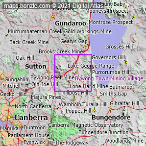
 myBonzle menu: Add to my places   Add picture   Add story   Add note   

Skip to map  

Where is Bywong Town Mining Village?

Bywong Town Mining Village is in the southeast of New South Wales which is in the east of Australia.

What is the latitude and longitude of Bywong Town Mining Village?

Bywong Town Mining Village is at a latitude of -35.16731 decimal degrees and a longitude of 149.32642 decimal degrees (GDA94 datum, which is for many practical purposes equivalent to WGS84). Latitude and longitude coordinates may be represented in a variety of different numeric formats:

FormatLatitudeLongitude
Decimal-35.16731°149.32642°
D° MM' SS"35° 10' 02" S149° 19' 35" E
D° MM.MMM'35° 10.039' S149° 19.585' E

What is the elevation/altitude/height above sea level of Bywong Town Mining Village?

Bywong Town Mining Village is at an elevation/altitude/height above sea level of 768 m above sea level.

What is the nearest city, town or village to Bywong Town Mining Village?

The nearest village to Bywong Town Mining Village is Sutton about 6.7 km away. Sutton has a population of about around 260 (based on the 2001 census). Click here for a map showing Bywong Town Mining Village and Sutton.

What is the annual rainfall of Bywong Town Mining Village?

The annual rainfall of Bywong Town Mining Village is about 623 mm.

What is the most rain Bywong Town Mining Village has ever received in a day?

The most rain received by Bywong Town Mining Village in a day was 126 mm. The most rain received by Bywong Town Mining Village in a December day was around 87 mm.

In what local government area (LGA) is Bywong Town Mining Village?

Bywong Town Mining Village is in the local government area of 'Palerang'. The 'Palerang' local government area is classified as an 'Area'.

If you're interested in Localities then you may also be interested in Suburbs/Regional Areas, Cities, Towns and Villages and Cities, Towns and Villages.

Do you have a photo of Bywong Town Mining Village gathering cyber dust on your hard drive?   Why not upload it and share your information with other Bonzle users.   Click here to view recently uploaded photos from other users or browse thousands of pictures grouped by themes in Bonzle collections.   Here are some examples:

Parliament House Minnie Water Patawarta Hill Avalon

Create a custom map: Click here to create a custom map including 'Bywong Town Mining Village'

Link to this page: Click here to see how

Map of Bywong Town Mining Village in New South Wales
Click on the name of a place to go to the Bonzle page for that place. For other clicks on the map, select what click action you want below, then click on the map where you want that action performed.

ZOOM IN  ZOOM OUT  PAN/MOVE  GET HEIGHT/DEPTH & POSITION

scroll up and leftscroll up and leftscroll upscroll upscroll upscroll up and rightscroll up and right
scroll up and left
scroll up and right
scroll left
scroll left
scroll left
scroll right
scroll right
scroll right
scroll down and leftscroll down and right
scroll down and leftscroll down and leftscroll downscroll downscroll downscroll down and rightscroll down and right
< MAX INCLICK IN THE SHADED BAR BELOW TO SET THE ZOOM LEVELMAX OUT >
zoombar
Map Legend
2km
mapscalemapscalemapscale
1mi
colour of populated areasPopulated Areascolour of sandSand
colour of reserves and parksReserves and Parkscolour of native vegetationNative Vegetation
What's nearby
hide
myBonzlehide
Sign In | Not a member? Join now!
Searchhide
Position within Australiahide
Your locationhide
Places last visitedhide

Your screen sizehide

640 | 800 | 1024 | 1280 | 1400 | 1600

©2024 Digital Atlas Pty Limited | Usage Terms | Data Sources
If you do not agree with the Usage Terms then do not access this website.