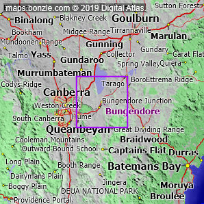
myBonzle menu: Add to my places Add picture Add story Add note Skip to map The map includes: - the following cities, towns and villages Queanbeyan (pop. around 30,000), Bungendore (pop. around 1,700) and Sutton (pop. around 260).
- a number of mountains and hills including Mount Palerang (1231m), Yarrow Peak (1071m), Balcombe Hill (939m), Hammonds Hill (921m), Poppet Hill (914m), Turalla Hill (912m), Bald Hill (895m), Taliesin Hills (894m), Gibraltar Hill (887m), Governors Hill (885m) and Purrorumba Hill (883m).
- a number of rivers and creeks including the Yass River, the Molonglo River, the Queanbeyan River, the Mulwaree River, Mulloon Creek, Brooks Creek, Butmaroo Creek, Turallo Creek, Boro Creek and Reedy Creek.
- a number of roads including Kings Highway, Federal Highway, Braidwood Road, Captains Flat Road, Sutton Road, Bungendore Road, Uriarra Road, Cooma Road, Gundaroo Drive and Canberra Avenue.
If you're interested in Cities, Towns and Villages then you may also be interested in Suburbs/Regional Areas. |