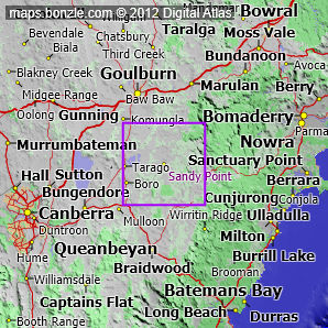
myBonzle menu: Add to my places Add picture Add story Add note Skip to map The map includes: - the village of Sandy Point (pop. around ).
- the mountains and hills Mount Coghill (809m), Round Hill (788m), Black Peaks (719m), Sunset Mountain (641m), Purgatory Hill (609m) and Bonanza Hill (575m).
- a number of rivers and creeks including the Shoalhaven River, the Mongarlowe River, the Mulwaree River, Boro Creek, the Endrick River, the Corang River, Bungonia Creek, Nadgigomar Creek, Reedy Creek and Budjong Creek.
- Braidwood Road.
If you're interested in Cities, Towns and Villages then you may also be interested in Suburbs/Regional Areas. |