Map of Meningie, SA

home > cities, towns and villages > Meningie > map of Meningie
bonzle.com logo
Description
General
Weather
People
FAQ
LGA
Terrain
Similar
Map Includes
>>>Contribute
Pictures
Notes
Stories
Submit website

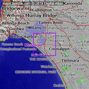
 myBonzle menu: Add to my places   Add picture   Add story   Add note   

Skip to map  

Featured picture
Picture of / about 'Meningie' South Australia - Meningie
Meningie
click here for 3 more pictures...

You'll find the village of Meningie on the Princes Highway in South Australia about 110km southeast of Adelaide (show me). Meningie is near the Southern Ocean. Meningie has a population of around 900 and is one of the smaller towns in Australia. Meningie is about 7m above sea level.

The nearest more populous place is the town of Tailem Bend which is 50km away with a population of around 1,400 (show me a map with Meningie and Tailem Bend).

Meningie is on the intersection of the Princes Highway and the McIntosh Road.

Bonzle users have said that the facilities at Meningie include an airport, caravan park or parks, child care centre, cycle paths, fire station, health centre, high school, hospital, hotel/motel, police station and service station. Do you know of other facilities available at Meningie? Is this list accurate? Contribute your knowledge by clicking here.

Are you a keen gardener? Do you know what edible garden plants grow at Meningie? Contribute your knowledge by clicking here.

Bonzle users have reported that the following vermin (feral animals, insects and weeds) have invaded Meningie: gorse. Do you know of other feral animals, insects and weeds that have invaded Meningie? Is this list accurate? Contribute your knowledge by clicking here.

Do you know of any agricultural activities in Meningie? Contribute your knowledge by clicking here.

If you're interested in Cities, Towns and Villages then you may also be interested in Suburbs/Regional Areas.

Do you have a photo of Meningie gathering cyber dust on your hard drive?   Why not upload it and share your information with other Bonzle users.   Click here to view recently uploaded photos from other users or browse thousands of pictures grouped by themes in Bonzle collections.   Here are some examples:

Picture relating to Dangars Falls - titled 'Dangars Falls'Dangars Falls Picture relating to Molong - titled 'Molong'Molong Picture relating to Tenterfield - titled 'View of Tenterfield, New South Wales, 1887'Tenterfield Picture relating to Angaston - titled 'Angaston'Angaston

Not the 'Meningie' you were after? Try the other Meningie (the regional area) in South Australia.

Create a custom map: Click here to create a custom map including 'Meningie'

Link to this page: Click here to see how

Map of Meningie in South Australia
Click on the name of a place to go to the Bonzle page for that place. For other clicks on the map, select what click action you want below, then click on the map where you want that action performed.

ZOOM IN  ZOOM OUT  PAN/MOVE  GET HEIGHT/DEPTH & POSITION

scroll up and leftscroll up and leftscroll upscroll upscroll upscroll up and rightscroll up and right
scroll up and left
scroll up and right
scroll left
scroll left
scroll left
scroll right
scroll right
scroll right
scroll down and leftscroll down and right
scroll down and leftscroll down and leftscroll downscroll downscroll downscroll down and rightscroll down and right
< MAX INCLICK IN THE SHADED BAR BELOW TO SET THE ZOOM LEVELMAX OUT >
zoombar
Map Legend
8km
mapscalemapscalemapscale
5mi
colour of populated areasPopulated Areascolour of sandSand
colour of reserves and parksReserves and Parkscolour of native vegetationNative Vegetation
What's nearby
hide
myBonzlehide
Sign In | Not a member? Join now!
Searchhide
Position within Australiahide
Your locationhide
Places last visitedhide

Naturi in South Australia

Your screen sizehide

640 | 800 | 1024 | 1280 | 1400 | 1600

©2024 Digital Atlas Pty Limited | Usage Terms | Data Sources
If you do not agree with the Usage Terms then do not access this website.