Map of Wandin Yallock Creek, VIC

home > rivers and creeks > Wandin Yallock Creek > map of Wandin Yallock Creek
bonzle.com logo
Description
General
FAQ
Tributaries
Map Includes
>>>Contribute
Pictures
Notes
Stories
Submit website

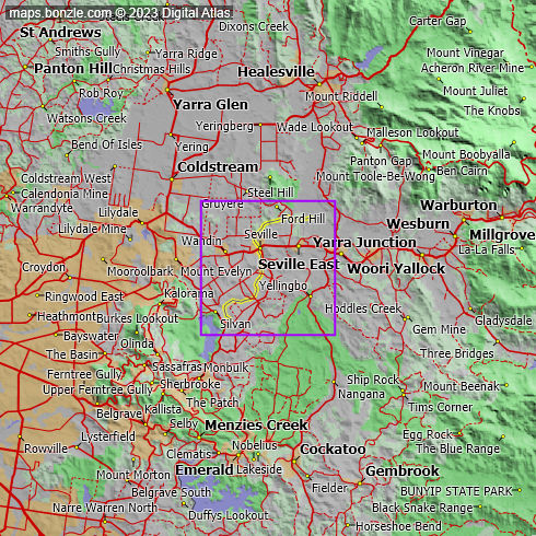
 myBonzle menu: Add to my places   Add picture   Add story   Add note   

Skip to map  

Do you have a picture of 'Wandin Yallock Creek'?
Do you have a picture of 'Wandin Yallock Creek'? If so, upload it.
Share your Australia - add a picture

Wandin Yallock Creek in south Victoria starts below Silvan at an elevation of 264m at an elevation of 87.8m .

The Wandin Yallock Creek drops around 176m over its 15.2km length.

Wandin Yallock Creek is highlighted in yellow on the map below.

Have you caught or seen fish at Wandin Yallock Creek? Contribute your knowledge by clicking here.

Are you a keen bird watcher? Have you been bird watching at Wandin Yallock Creek? What birds have you seen at Wandin Yallock Creek? Contribute your knowledge by clicking here. As a Bonzle sub-project, we're trying to build Australia's most comprehensive bird location atlas. A big thankyou to all that have contributed and continue to contribute sightings.

Do you know what facilities are available at Wandin Yallock Creek? Contribute your knowledge by clicking here.

Do you know what recreational activities are available at Wandin Yallock Creek? Contribute your knowledge by clicking here.

If you're interested in Rivers and Creeks then you may also be interested in Springs, Waterfalls, Lakes and Dams and Gorges.

Do you have a photo of Wandin Yallock Creek gathering cyber dust on your hard drive?   Why not upload it and share your information with other Bonzle users.   Click here to view recently uploaded photos from other users or browse thousands of pictures grouped by themes in Bonzle collections.   Here are some examples:

Picture relating to Glenlyon - titled 'Glenlyon'Glenlyon Picture relating to Katherine - titled 'Cattle at Manbulloo station Katherine NT'Katherine Picture relating to Mooloolaba - titled 'Tin Can Bay'Mooloolaba Picture relating to Queensland - titled 'Workers in the bush, 1910-1920'Queensland

Create a custom map: Click here to create a custom map including 'Wandin Yallock Creek'

Link to this page: Click here to see how

Map of Wandin Yallock Creek in Victoria
Click on the name of a place to go to the Bonzle page for that place. For other clicks on the map, select what click action you want below, then click on the map where you want that action performed.

ZOOM IN  ZOOM OUT  PAN/MOVE  GET HEIGHT/DEPTH & POSITION

scroll up and leftscroll up and leftscroll upscroll upscroll upscroll up and rightscroll up and right
scroll up and left
scroll up and right
scroll left
scroll left
scroll left
scroll right
scroll right
scroll right
scroll down and leftscroll down and right
scroll down and leftscroll down and leftscroll downscroll downscroll downscroll down and rightscroll down and right
< MAX INCLICK IN THE SHADED BAR BELOW TO SET THE ZOOM LEVELMAX OUT >
zoombar
Map Legend
2km
mapscalemapscalemapscale
1mi
colour of populated areasPopulated Areascolour of sandSand
colour of reserves and parksReserves and Parkscolour of native vegetationNative Vegetation
hide
myBonzlehide
Sign In | Not a member? Join now!
Searchhide
Position within Australiahide
Your locationhide
Places last visitedhide
Your screen sizehide

640 | 800 | 1024 | 1280 | 1400 | 1600

©2023 Digital Atlas Pty Limited | Usage Terms | Data Sources
If you do not agree with the Usage Terms then do not access this website.