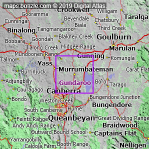
myBonzle menu: Add to my places Add picture Add story Add note Skip to map The map includes: - the following cities, towns and villages Hall (pop. around 350), Sutton (pop. around 260) and Gundaroo (pop. around 240).
- a number of mountains and hills including Purrorumba Hill (883m), Mount Spring (870m), One Tree Hill (855m), Old Joe Hill (809m), Piccaree Hill (800m), Oak Hill (785m), Gecko Hills (783m), Sammy's Hill (721m), Nanima Hill (714m), Mount Rogers (697m) and Burnt Stump Hill (695m).
- a number of rivers and creeks including the Yass River, Brooks Creek, Butmaroo Creek, Murrumbateman Creek, Turallo Creek, Jeir Creek, Ginninderra Creek, Collector Creek, Gooda Creek and Back Creek.
- a number of roads including Federal Highway, Barton Highway, Sutton Road, Gundaroo Road, Bungendore Road, Gundaroo Drive, Nanima Road, Macs Reef Road, Kingsford Smith Drive and Gungahlin Drive.
If you're interested in Cities, Towns and Villages then you may also be interested in Suburbs/Regional Areas. |