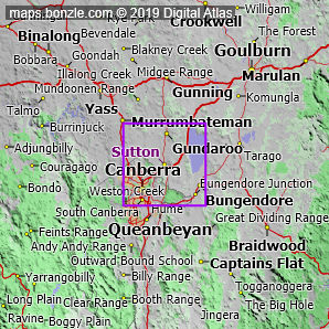
myBonzle menu: Add to my places Add picture Add story Add note Skip to map The map includes: - the following cities, towns and villages Canberra (pop. about 310,000), Bungendore (pop. around 1,700), Hall (pop. around 350), Sutton (pop. around 260) and Gundaroo (pop. around 240).
- a number of mountains and hills including Poppet Hill (914m), Turalla Hill (912m), Bald Hill (895m), Purrorumba Hill (883m), Millpost Hill (882m), Mount Majura (880m), Mount Spring (870m), One Tree Hill (855m), Mount Ainslie (836m), Old Joe Hill (809m) and Piccaree Hill (800m).
- a number of rivers and creeks including the Yass River, the Molonglo River, the Queanbeyan River, Brooks Creek, Butmaroo Creek, Jerrabomberra Creek, Murrumbateman Creek, Turallo Creek, Jeir Creek and Ginninderra Creek.
- a number of roads including Monaro Highway, Kings Highway, Federal Highway, Barton Highway, Sutton Road, Gundaroo Road, Bungendore Road, Uriarra Road, Gundaroo Drive and Cotter Road.
If you're interested in Cities, Towns and Villages then you may also be interested in Suburbs/Regional Areas. |