Map of Merriangaah Nature Reserve, NSW

home > nature conservation reserves > Merriangaah Nature Reserve > map of Merriangaah Nature Reserve
bonzle.com logo
Description
General
Map Includes
>>>Contribute
Pictures
Notes
Stories
Submit website

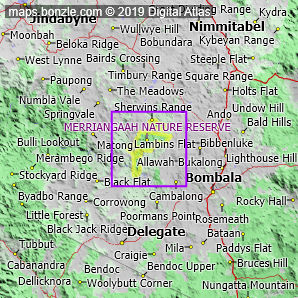
 myBonzle menu: Add to my places   Add picture   Add story   Add note   

Skip to map  

Do you have a picture of 'Merriangaah Nature Reserve'?
Do you have a picture of 'Merriangaah Nature Reserve'? If so, upload it.
Share your Australia - add a picture

Merriangaah Nature Reserve covers an area of around 5,800 hectares and is located in the southeast of Australia. Merriangaah Nature Reserve is in NSW.

Towns, villages or cities in and around Merriangaah Nature Reserve include the town of Bombala (show me), the village of Delegate (show me) and the village of Nimmitabel (show me).

Are you a keen bird watcher? Have you been bird watching in Merriangaah Nature Reserve? What birds have you seen in Merriangaah Nature Reserve? Contribute your knowledge by clicking here. As a Bonzle sub-project, we're trying to build Australia's most comprehensive bird location atlas. A big thankyou to all that have contributed and continue to contribute sightings.

Do you know what facilities are available in Merriangaah Nature Reserve? Contribute your knowledge by clicking here.

Do you know what recreational activities are available in Merriangaah Nature Reserve? Contribute your knowledge by clicking here.

Do you know whether any feral animals, insects and weeds have invaded Merriangaah Nature Reserve? Contribute your knowledge by clicking here.

If you're interested in Nature Conservation Reserves then you may also be interested in Forestry Reserves and Deserts.

Do you have a photo of Merriangaah Nature Reserve gathering cyber dust on your hard drive?   Why not upload it and share your information with other Bonzle users.   Click here to view recently uploaded photos from other users or browse thousands of pictures grouped by themes in Bonzle collections.   Here are some examples:

Picture relating to Hamilton Highway - titled 'Hamilton Highway at Hexham'Hamilton Highway Picture relating to Mount Barker - titled 'Zambonetti Transport'Mount Barker Picture relating to Goodger - titled 'Goodger shop (now closed)'Goodger Picture relating to Archerfield - titled 'Aircraft mechanics working on an Avro Anson Mk1 plane, Archerfield, ca. 1942'Archerfield

Create a custom map: Click here to create a custom map including 'Merriangaah Nature Reserve'

Link to this page: Click here to see how

Map of Merriangaah Nature Reserve in New South Wales
Click on the name of a place to go to the Bonzle page for that place. For other clicks on the map, select what click action you want below, then click on the map where you want that action performed.

ZOOM IN  ZOOM OUT  PAN/MOVE  GET HEIGHT/DEPTH & POSITION

scroll up and leftscroll up and leftscroll upscroll upscroll upscroll up and rightscroll up and right
scroll up and left
scroll up and right
scroll left
scroll left
scroll left
scroll right
scroll right
scroll right
scroll down and leftscroll down and right
scroll down and leftscroll down and leftscroll downscroll downscroll downscroll down and rightscroll down and right
< MAX INCLICK IN THE SHADED BAR BELOW TO SET THE ZOOM LEVELMAX OUT >
zoombar
Map Legend
4km
mapscalemapscalemapscale
3mi
colour of populated areasPopulated Areascolour of sandSand
colour of reserves and parksReserves and Parkscolour of native vegetationNative Vegetation
hide
myBonzlehide
Sign In | Not a member? Join now!
Searchhide
Position within Australiahide
Your locationhide
Places last visitedhide

Nerobingabla Creek in New South Wales
Naturi in South Australia
Adelaide in South Australia
Tailem Bend in South Australia
Arkaba Creek in South Australia

Your screen sizehide

640 | 800 | 1024 | 1280 | 1400 | 1600

©2024 Digital Atlas Pty Limited | Usage Terms | Data Sources
If you do not agree with the Usage Terms then do not access this website.