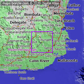
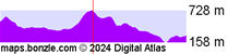
myBonzle menu: Add to my places Add picture Add story Add note Skip to map Mount Merragunegin is a mountain located near the South Pacific Ocean within the Coopracambra National Park in the east of Victoria. Mount Merragunegin is at an altitude of about 721m above sea level. The nearest towns, villages or cities to Mount Merragunegin are the town of Mallacoota (38.4km away - show me), the village of Cann River (39.1km away - show me) and the town of Bombala (48.4km away - show me). The nearest road to Mount Merragunegin is an unsealed road that is un-named in our database (1.48km away). The nearest sealed road to Mount Merragunegin is the Monaro Highway (16.6km away).
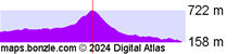
Do you know what facilities are available at Mount Merragunegin? Contribute your knowledge by clicking here. Do you know what recreational activities are available at Mount Merragunegin? Contribute your knowledge by clicking here. Are you a keen bird watcher? Have you been bird watching at Mount Merragunegin? What birds have you seen at Mount Merragunegin? Contribute your knowledge by clicking here. As a Bonzle sub-project, we're trying to build Australia's most comprehensive bird location atlas. A big thankyou to all that have contributed and continue to contribute sightings. Click here for detailed terrain profiles which show the topography around Mount Merragunegin. 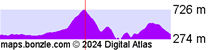 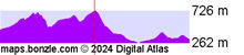
|