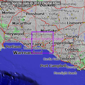
myBonzle menu: Add to my places Add picture Add story Add note Skip to map Warrnambool Weather Station is located in the southwest of Victoria at an altitude of about 71m above sea level. Warrnambool Weather Station is close to Koroit (7.24km away - show me), Warrnambool (10.7km away - show me) and Allansford (16.5km away - show me). Nearby localities include: Mailors Flat (2.09km away - show me), Yarpturk (2.13km away - show me), Yangery (3.33km away - show me), Woodford (3.84km away - show me), Southern Cross (4.13km away - show me), Winslow (5.35km away - show me), Illowa (6.19km away - show me), Bushfield (6.22km away - show me), Grassmere (6.58km away - show me) and Grassmere Junction (7.52km away - show me). The two closest weather stations to Warrnambool Weather Station are the Port Fairy Weather Station 22.2km away to the southwest and the Mortlake Weather Station 36.5km away to the southwest (show me a map of all three weather stations). The nearest road to Warrnambool Weather Station is a sealed road that is un-named in our database and comes within 542m of Warrnambool Weather Station. The nearest sealed road to Warrnambool Weather Station is the Mailors Flat Koroit Road (1.3km away).
Last 20 observations from Warrnambool Weather Station| Local time | Time ago | Temperature | Feels like | Pressure | Wind speed | Wind direction | Relative humidity | Rain since 9AM |
|---|
|