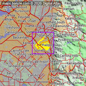
myBonzle menu: Add to my places Add picture Add story Add note Skip to map Maddington is a suburb of southeast Perth in southwest Western Australia and has a population of around 9,100 (49.3% male, 50.7% female). Around 2457 families live in the area and of those 39.6% have one or more children under the age of 15. 20.9% of families have only a single parent while 37.4% of couples have no children. Maddington covers an area of approximately 1083 hectares or around 11 square kilometres (km2) (2677 acres). The most common income bracket for people living in Maddington is between $400-$599 per week (16.8% of people). 6.7% have no income and high income earners ($2000 or more per week) account for 0.8% of the population. Of the 3444 private dwellings in Maddington 28% are owned outright by their occupiers, 43% are being purchased (eg. by mortgage) and 23% are being rented. On average there are around 2.7 people per private dwelling in the area. The composition of occupied private dwellings in Maddington is as follows: 82.9% separate houses, 6.8% semi-detached houses (eg. townhouses, row or terrace houses), 10.3% flats (including units and apartments). In terms of people aged 15 years or more living in Maddington 43% are married, 10% are divorced, 4% are separated, 6% are widowed and 37% have never married. Compared to the rest of Australia, Maddington has an above average migrant population, with around 36.9% of residents being born overseas. The top 5 countries of birth for migrants in the area are: United Kingdom (10.9%), New Zealand (2.8%), Italy (1.7%), India (1.5%), Philippines (0.8%). Maddington varies in altitude/elevation from about 1 m (highlight point) to 35 m (highlight point) above sea level. The postcode for Maddington is 6109. Neighbouring suburbs/regional areas of Maddington include Gosnells, Kenwick, Martin, Martin, Orange Grove, Thornlie and Wattle Grove.
Bonzle users have said that the facilities in Maddington include a fire station, high school, hotel/motel, medical centre, pre school, primary school, railway station, shops and sportsground. Do you know of other facilities available in Maddington? Is this list accurate? Contribute your knowledge by clicking here. Do you know what recreational activities are available in Maddington? Contribute your knowledge by clicking here. Are you a keen gardener? Do you know what edible garden plants grow in Maddington? Contribute your knowledge by clicking here. Do you know whether any feral animals, insects and weeds have invaded Maddington? Contribute your knowledge by clicking here. Do you know of any agricultural activities in Maddington? Contribute your knowledge by clicking here.Are you a keen bird watcher? Have you been bird watching in Maddington? What birds have you seen in Maddington? Contribute your knowledge by clicking here. As a Bonzle sub-project, we're trying to build Australia's most comprehensive suburb by suburb bird location atlas. A big thankyou to all that have contributed and continue to contribute sightings. The areas that make up this are outlined in yellow on the map below. If you're interested in Suburbs/Regional Areas then you may also be interested in Cities, Towns and Villages and Cities, Towns and Villages. |