Map of Moorindoorah, QLD

home > homesteads > Moorindoorah > map of Moorindoorah
bonzle.com logo
Description
General
Weather
FAQ
Terrain
Map Includes
>>>Contribute
Pictures
Notes
Stories
Submit website

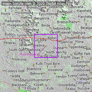
 myBonzle menu: Add to my places   Add picture   Add story   Add note   

Skip to map  

Do you have a picture of 'Moorindoorah'?
Do you have a picture of 'Moorindoorah'? If so, upload it.
Share your Australia - add a picture

You'll find the homestead of Moorindoorah in Queensland about 570km west of Brisbane (show me). Moorindoorah is at an altitude of about 180m above sea level. The nearest sea is the Coral Sea which is part of the South Pacific Ocean about 570km east of Moorindoorah.

The nearest more populous place is the village of Dirranbandi which is 110km away with a population of around 530 (show me a map with Moorindoorah and Dirranbandi).

Do you know what condition Moorindoorah is in? Contribute your knowledge by clicking here.

Do you know what facilities are available at Moorindoorah? Contribute your knowledge by clicking here.

Are you a keen gardener? Do you know what edible garden plants grow at Moorindoorah? Contribute your knowledge by clicking here.

Do you know whether any feral animals, insects and weeds have invaded Moorindoorah? Contribute your knowledge by clicking here.

Do you know of any agricultural activities in Moorindoorah? Contribute your knowledge by clicking here.

Do you have a photo of Moorindoorah gathering cyber dust on your hard drive?   Why not upload it and share your information with other Bonzle users.   Click here to view recently uploaded photos from other users or browse thousands of pictures grouped by themes in Bonzle collections.   Here are some examples:

Picture relating to City Hill - titled 'Aerial view of Civic Centre looking up Northbourne Avenue, from over City Hill.'City Hill Picture relating to Brisbane - titled 'Brisbane'Brisbane Picture relating to Chichester Range - titled 'Picturesque Sunset Kelmscott WA'Chichester Range Picture relating to Quorn - titled 'Quorn SA - Pichi Richi Railway'Quorn

Create a custom map: Click here to create a custom map including 'Moorindoorah'

Link to this page: Click here to see how

Map of Moorindoorah in Queensland
Click on the name of a place to go to the Bonzle page for that place. For other clicks on the map, select what click action you want below, then click on the map where you want that action performed.

ZOOM IN  ZOOM OUT  PAN/MOVE  GET HEIGHT/DEPTH & POSITION

scroll up and leftscroll up and leftscroll upscroll upscroll upscroll up and rightscroll up and right
scroll up and left
scroll up and right
scroll left
scroll left
scroll left
scroll right
scroll right
scroll right
scroll down and leftscroll down and right
scroll down and leftscroll down and leftscroll downscroll downscroll downscroll down and rightscroll down and right
< MAX INCLICK IN THE SHADED BAR BELOW TO SET THE ZOOM LEVELMAX OUT >
zoombar
Map Legend
8km
mapscalemapscalemapscale
5mi
colour of populated areasPopulated Areascolour of sandSand
colour of reserves and parksReserves and Parkscolour of native vegetationNative Vegetation
What's nearby
hide
myBonzlehide
Sign In | Not a member? Join now!
Searchhide
Position within Australiahide
Your locationhide
Places last visitedhide

Naturi in South Australia
Strathalbyn in South Australia
Karoonda Road in South Australia
Menincourt in New South Wales
Mount Merragunegin in Victoria
Moorilyanna Hill in South Australia
Merlynston in Victoria
Karoonda in South Australia
Tailem Bend in South Australia

Your screen sizehide

640 | 800 | 1024 | 1280 | 1400 | 1600

©2024 Digital Atlas Pty Limited | Usage Terms | Data Sources
If you do not agree with the Usage Terms then do not access this website.