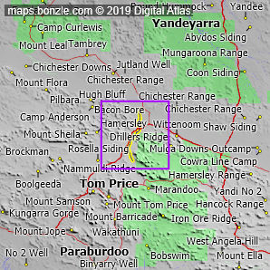
myBonzle menu: Add to my places Add picture Add story Add note Skip to map Fortescue River South in west Western Australia starts at an elevation of 650m and ends at an elevation of 392m flowing into the Fortescue River. The Fortescue River South drops around 259m over its 62.2km length. Fortescue River South is highlighted in yellow on the map below.
Have you caught or seen fish at Fortescue River South? Contribute your knowledge by clicking here. Are you a keen bird watcher? Have you been bird watching at Fortescue River South? What birds have you seen at Fortescue River South? Contribute your knowledge by clicking here. As a Bonzle sub-project, we're trying to build Australia's most comprehensive bird location atlas. A big thankyou to all that have contributed and continue to contribute sightings. Do you know what facilities are available at Fortescue River South? Contribute your knowledge by clicking here. Do you know what recreational activities are available at Fortescue River South? Contribute your knowledge by clicking here. If you're interested in Rivers and Creeks then you may also be interested in Springs, Waterfalls, Lakes and Dams and Gorges. Do you have a photo of Fortescue River South gathering cyber dust on your hard drive? Why not upload it and share your information with other Bonzle users. Click here to view recently uploaded photos from other users or browse thousands of pictures grouped by themes in Bonzle collections. Here are some examples: Kynuna St Helens Hobart Manuka |