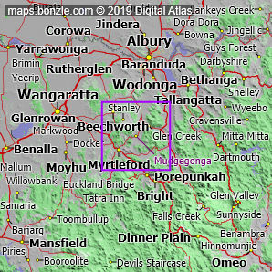
myBonzle menu: Add to my places Add picture Add story Add note Skip to map You'll find the locality of Mudgegonga on the Myrtleford Yackandandah Road nestled amongst mountains such as Goat Knob (610m) and Mount Stanley (1049m) in east Victoria. Mudgegonga is about 220km northeast of Melbourne (show me). Mudgegonga is about 313m above sea level. The nearest sea is the Tasman Sea which is part of the South Pacific Ocean about 180km south-southeast of Mudgegonga. Mudgegonga is on the Barwidgee Creek. The nearest more populous place is the town of Myrtleford which is 13km away with a population of around 2,500 (show me a map with Mudgegonga and Myrtleford).
Do you know what facilities are available at Mudgegonga? Contribute your knowledge by clicking here. Do you know what recreational activities are available at Mudgegonga? Contribute your knowledge by clicking here. Are you a keen gardener? Do you know what edible garden plants grow at Mudgegonga? Contribute your knowledge by clicking here. Do you know whether any feral animals, insects and weeds have invaded Mudgegonga? Contribute your knowledge by clicking here. Do you know of any agricultural activities in Mudgegonga? Contribute your knowledge by clicking here.If you're interested in Localities then you may also be interested in Suburbs/Regional Areas, Cities, Towns and Villages and Cities, Towns and Villages. |